In the classic song “In the Summertime,” Mungo Jerry sings: In the summertime when the weather is hot / You can stretch right up and touch the sky. The lyric elicits the familiar feeling of summer, a sensation of heat-induced laziness where you might stretch your arms up to the sky and let out a sigh. Yet the bright blue skies and warm weather that we associate with summer also come with heightened exposure to air pollution.
Aclima’s Chief Scientist, Melissa Lunden, talks about how seasonal shifts affect air quality in the summer and how environmental data can increase our understanding of how those changes affect our health.
What are the main factors that contribute to poor air quality in the summer?
Conditions in the summer are ripe for the production of pollutants that form through photochemistry. Photochemistry happens when sunlight reacts with pollutants like oxides of nitrogen or volatile organic compounds (VOCs) to produce other pollutants like ozone (O3) or particulate matter (PM). With longer days comes more sunlight that drives photochemistry. This mixture of pollution in the smog is what gives the air a characteristic brown color that is seen in metropolitan areas, such as downtown Los Angeles.
Weather is also a big factor affecting air quality. Pollution is magnified by stagnant air. Air that is closer to the Earth’s surface is usually warmer than the air above it. In regions with bad smog, a layer of warm air traps cooler air at the surface and prevents it from rising, forming what is called an inversion. The inversion layer acts like a lid, trapping pollutants for days or even weeks. For example, Los Angeles forms natural inversion layers regularly, on the order of 260 days a year, and the smog doesn’t break up until a storm or other types of weather system come through — and those are pretty rare in California in the summer.

What else causes poor air quality?
Besides reacting to warmer weather, summertime marks that onset of fire season in many parts of the country, some of which are experiencing prolonged periods of drought attributed to climate change. These factors are exacerbating and contributing to the severity, frequency, and size of fires across North America. Fires have significant impacts on air quality and human health; emissions can travel hundreds of miles and can even be seen from space. A fire burning in the Sierra Nevada mountains here in California can often impact air quality in the San Francisco Bay Area, seen as a white haze throughout the region. Fires are a major source of particulate matter, which are tiny solid or liquid particles suspended in air. Particles with diameters smaller than 2.5 micrometers, known as PM 2.5, are known to lodge deep in the lungs and cause serious respiratory and cardiac issues. Aclima is partnered with Lawrence Berkeley National Laboratory to develop the world’s smallest particulate matter sensor to bring a ubiquitous layer of data to the measurement of PM 2.5.
How do urban areas affect air quality in the summer?
In cities, a phenomenon known as the urban heat island (UHI) effect happens due to densely packed buildings. Pavement, roofs, and other building materials in cities are very good at absorbing solar radiation, leading to higher temperatures when compared to green space. Most of us have experienced this effect when trying to walk across hot pavement in the summer without shoes.
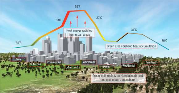
UHIs often have poor air quality because increased heat and pollution from vehicles leads to the creation of air pollutants. Even worse, the pollutants become trapped by the urban landscape as it can alter the local meteorology, blocking winds and preventing pollutants from dispersing. If we can better track and map how heat moves throughout a city, city planners can make smarter siting decisions for green spaces and identify high-risk populations affected during heat waves.
How can you avoid being exposed to air pollution?
To minimize your personal exposure to air pollution, stay indoors in a well-ventilated space on poor air days. Additionally, if you are exercising outside, avoid main highways by running a few blocks away from heavily-trafficked roads. The time of day you exercise also matters; it’s best to exercise early in the day when pollutant concentrations are usually lowest. There are also things you can do to reduce air pollution as an individual. The U.S. Environmental Protection Agency encourages urban and suburban residents to take public transportation, reduce vehicle trips, or choose low-emission forms of transportation. All of these activities will play a role in alleviating your contribution to summertime air pollution.
At a macro-level, we need to reduce the sources of air pollution — such as moving to low-emission vehicle fleets, clean and renewable power, and investing in energy efficiency measures. Utilizing big data to track and better understand whether climate goals are being met, on the ground and in our communities, helps us better understand the complex causes of climate change and develop systemic, targeted solutions to combat this global challenge.
What role does Aclima play in understanding air pollution?
Transportation, increased energy use, and how we design our cities all affect our environment, and ultimately, our health. While we may understand the mechanisms behind how air pollution is created, many unknowns still exist about how air quality ebbs and flows through a city, especially at the street level. Environmental sensor networks can bridge the knowledge gap by helping us map pollution at a hyper-local level, to inform effective solutions to improve urban air quality.
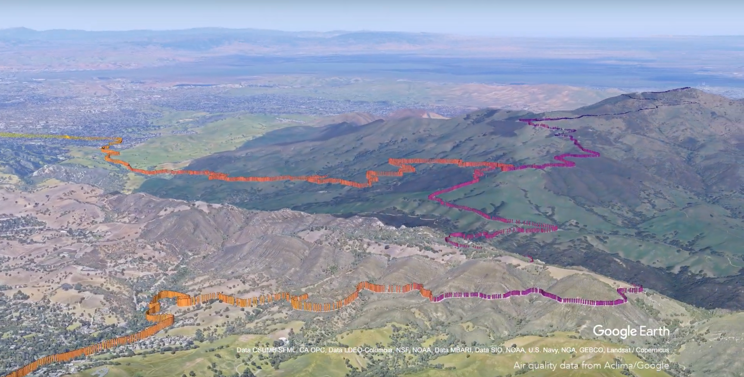
How can we use environmental data to change how we manage our cities and better understand the impact of solutions like green spaces and traffic flow? What role do transportation and urban planning have in affecting everyday air quality? These are some of the initial questions Aclima is working to answer in three of the largest cities in California. Last Fall, we announced a commitment with Google to map pollution in San Francisco, Los Angeles, and the Central Valley communities to better understand air quality at the street level and make these insights available to researchers and the public. Environmental intelligence allows us to connect the dots at the street-level and enable citizens and policymakers alike to make better decisions that benefit not only human health, but also our planet’s health.
Check out Melissa’s video to learn more about atmospheric science and Aclima.
Share this
Driving Science
Sensing Wildfire Smoke at the Street Level