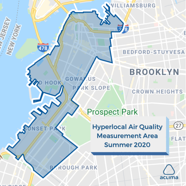
Aclima is now measuring air pollution and greenhouse gases block by block throughout Downtown Brooklyn and nearby potential environmental justice communities, including portions of Clinton Hill, Gowanus, Red Hook, and Sunset Park. The below map outlines the areas where our mobile sensing fleet is measuring this summer.
In June, our co-founder and CEO Davida Herzl shared our plans to launch our mobile sensing fleet in New York City this summer. In addition to sharing our coverage map today, we are also delighted to share the news that we have joined Downtown Brooklyn Partnership’s (DBP) Living Lab initiative, along with the NYU Center for Urban Science and Progress and Walkspan. DBP’s Living Lab is focused on implementing smart cities technologies to solve urban challenges, and DBP is a key supporting partner in Newlab’s Circular City Studio, which enables companies to pilot transformative technology throughout New York City to solve pressing challenges.
Air pollution exposure is not uniform. In fact, recent research we conducted with the EPA, EPRI, and Envair showed that air pollution can vary by as much as eight times or 800% from one block to the next. By measuring air pollution and greenhouse gases block by block throughout downtown Brooklyn, as well as adjacent potential environmental justice areas, we’ll be able to provide key insights into the three-month average of emissions and exposures at the street-level.
Understanding the localized impacts of emissions is critical for protecting public health. In 2014, the World Health Organization estimated that about seven million people die prematurely annually as a result of exposure to air pollution, and long-term exposure to relatively small amounts can impact every organ in the human body through every phase of life. Recent research has shown a strong correlation between higher exposure to air pollutants including fine particulate matter and adverse COVID-19 outcomes, including higher death rates.
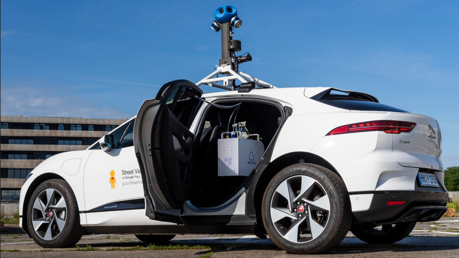
To deploy its mobile sensing network, Aclima engineers and technicians upfit low or no emissions vehicles with Aclima’s breakthrough sensing devices. As the cars drive through city streets, air samples pass through a specially designed intake and are then routed to the device for initial analysis. A combination of sensors and communications components geotag the air quality data points and continuously stream these hyperlocal measurements to the cloud. Each week, Aclima sends billions of new air quality data points to our cloud-based software, Aclima Pro, for use by governments, communities, and businesses to inform actions that reduce emissions and their impacts.
Aclima has hired sensing network operators from the community who are gathering representative measurements with our mobile platform — day and night, weekdays and weekends.
Results from Aclima’s first hyperlocal measurement campaign in New York will be shared publicly later this year at a showcase as part of the Circular City Studio.
Share this
New Interactive Report: San Diego Portside and Border Community Air Quality
Aclima and Google Now Measuring Air Pollution and GHGs Block by Block in Hamburg
